Pointe Sat Kompas Manuel utilisateur
PDF
Документ
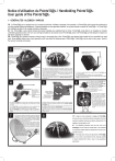
Notice d’utilisation du Pointe’S@t® / Handleiding Pointe’S@t® User guide of the Pointe’S@t® 1 - GÉNÉRALITÉS / Algemeen / Various FR : Le Pointe’S@t® est un appareil muni d’un compas de précision, facilitant le pointage d’une parabole. Le Pointe’S@t® doit toujours être positionné le plus loin possible d’éléments métalliques. Certaines paraboles ont une géométrie médiocre, ce qui peut fausser la mesure du Pointe’S@t®. Le Pointe’S@t® est réutilisable et idéal lors de voyages (camping, caravanes). NL : De Pointe’S@t® is een precisie kompas die toelaat makkelijk een satellietschotel te richten. Pointe’S@t® moet altijd zo ver mogelijk van metalen onderdelen geplaatst worden. De vorm van sommige schotels kan de precisie van de Pointe’S@t® storen. De Pointe’S@t® is herbruikbaar en ideaal voor het reizen (camping en caravan). GB : Pointe’S@t® is a precision compass, making it easy to accurately align a dish. Pointe’S@t® must always been located as for as possible from metal parts. Some satellite antenna have a poor geometry, which may distort the measurement of Pointe’S@t®. Pointe’S@t® can be used in many ways : Ideal for the vacancy (camping-caravaning). 1 2 Dôme/koepel/dome 3 Pastille blanche/ wit beschermingsvel / White protective sheet Repère blanc de pointage wite richting aanduider White line-up mark Repères de compensation/ unit /Equalization mark Corps/Body FR : Aligner avec précision le repère blanc de pointage (du dôme du compas) 4 Pointe’S@t® sur la valeur de compensation donnée dans le tableau de réglage géographique France ou Europe. (dans notre exemple : 0°) NL : Op een precieze wijze de witte richtingzandruiter van de koepel, in lijn zetten met de compensatie waarde gegeven in de geografische regelingstabel (Frankrijk of Europa, in ons voorbeeld 0°). GB : Align precisely the white line-up mark (the one on the dome of the compass), on the value of equalization indicated in the geographic adjustment table. (In our example : 0°) 5 FR : Retirer la pastille blanche sous la patte de fixation du Pointe’S@t® mais surtout ne pas la jeter. NL : Het wit beschermingsvel verwijderen maar vooral niet weggooien. GB : Remove the white protective sheet of the self-adhive fixation plate of Poin- te’S@t® but do NOT throw it away. 6 FR : Coller le Pointe’S@t® sur la bride de fixation du LNB (dans le sens indiqué sur le dessin ci -dessus). Pour le centrage guidez-vous du trait blanc sur la patte autocollante. NL : De Pointe’S@t® op de LNB bevestiging kleven (zoals op afbeelding), gebruik de witte lijn op de zelfklevende pallet om hem correct te plaatsen. GB : Stick Pointe’S@t® on the fixation clamp of the LNB (in the direction indicated on the drawing above). For centring,help out with the white mark on the plate. 7 FR : Placez-vous derrière votre parabole et après avoir desserré suffisament les vis de fixation sur le mat, réglez l’azimut (gauche/ droite) jusqu’à ce que le nom du satellite recherché soit aligné derrière le repère blanc du dôme (figure 8). Si votre démodulateur est analogique vous devez capter une image, si il est numérique son barre-graphe doit indiquer un signal. NL : Plaats U achter de schotel na de vijzen lichtjes te hebben losgedraaid om het azimut te regelen (links-rechts) tot de naam van de gezochte satelliet achter de witte markering van de koepel komt te staan (zie afbeelding 8). Als uw demodulator analogisch werkt heeft U nu een beeld, als hij digitaal werkt toont de satfinder bar-graph een signaal. GB : Stand behind the dish and after loosening the nuts slightly on the mount, adjust the azimuth (left/right) until the name of the required satellite is as precisely as possible positionned behind the white line-up mark on the side of the dome (see FIGURE 8). If you are using an analogue receiver, you must see an image, if it is a digital one, its bar-graph must indicate a signal. FR : Régler l’élévation (haut bas) de la parabole à l’aide du tableau de réglage géométrique. Cette image représente la fixation arrière de l’antenne, l’élévation est ici réglée à 33. NL : Regel de antenne dankzij de géometrische tabel. De afbeelding toont de bevestiging achter de antenne, hier op 33° geregeld. GB : Adjust the elevation (up/down) of the dish using the geographic adjustement table. The image above shows the back fixation of the dish, with an adjustment elevation value 33. 8 FR : Aidez-vous pour ce réglage de LNB tête électronique LNB kop LNB electronic head Repère d’élévation Elevatie markering Elevation mark Réglette d’élévation Elevatie gradering Small ruler of elevation Bride de fixation du LNB/ bevestiging LNB /Fixation clamp of the LNB FR : Régler le niveau du Pointe’S@t® (haut/ bas) afin que le dôme soit horizontal. NL : regel het niveau van de Pointe’S@t® zodat de koepel horizontaal staat. GB : Adjust the level of Pointe’S@t® (up/ down) until the dome is horizontal. Repère blanc de centragede la bulle Witte markering voor de regeling van de luchtbel Write mark for centring the air-lock Trait blanc sur la patte autocollante/ witte lijn op de zelfklevende palet /White mark on the self-adhesive Bulle Air-lock Egale Egale Equal Equal Luchtbel links en rechts egaal la bulle de niveau au sommet du dôme, en alignant cette dernière sur le repère blanc de centrage de la bulle (photo à gauche). NL : Plaats de luchtbel op de witte luchtbel markering van de koepel. GB : For this adjustment use the air-lock level at the top of the dome by aligning the air-lock on the white mark of the dome (see drawing on the left). FR : L’image ci-contre représente le réglage du Point’S@t® tel que je le vois en étant placé derrière la parabole. Dans cet exemple le satellite recherché est télécom (Atlantic Bird 3 le reglage de compensation est 0). NL : De afbeelding hieronder toont wat men ziet op de Point’S@t® als men achter de schotel staat. In dit voorbeeld is de gezochte satelliet Telecom (Atlantic Bird 3 met een compensatie niveau 0). GB : The image above shows the adjustment of Point’S@t® pt as I see it when I stand behind the dish. Example satellite is Telecom (Altantic Bird 3 with a value of 0 as equalization adjustment). 2 - Exemple / voorbeeld / example FR : Exemple de calage à lire simplement afin de vous familiariser avec le produit. - J’habite en france à Caen dans le département N°14 et je veux capter le satellite Atlantic Bird 3. NL : Voorbeeld te lezen om gewend te raken met het product. - Ik woon in Frankrijk in Caen in departement n°14 en wil Atlantic Bird 3 verkrijgen. GB : Please read this example of alignment of the dish in order to gain knowledge of the product. - I am living in France, in Caen (N°14) and I need to receive the satellite Atlantic Bird 3. Localisation/ Lokalisatie /Location France : N° Dept (vois tableau N°1) Land (zie tabel 2) Others : countries and cities (see table N°2) 14 Elévation Elevatie Elevation SAT : Atlantic Bird 3 Réglages compas Kompas regeling Compass adjustement 33° 0° 3 - EFFECTUER VOTRE CALAGE / de schotel richten / ALIGNMENT OF A DISH FR : Relier le câble coaxial du LNB sur votre démodulateur. Relier le cordon péritel du démodulateur sur votre téléviseur, mettez en marche votre téléviseur et votre démodulateur que vous réglez sur une chaîne du satellite recherché. Choisir le satellite, relever les informations dans le tableau de réglages géographique et remplir le tableau ci-dessous : NL : De coaxiale kabel van de LNB aan de demodulator verbinden en deze aan uw TV toestel. Start uw TV op het satelliet kanaal en uw demodulator op een zender van de gewenste satelliet. Kies uw satelliet, noteer de info van de geografische tabel in de volgende vakken : GB : Connect the coaxial cable of the LNB on the receiver. Connect the scart plug of the receiver on the television. Turn on television and the receiver, and tune them to a channel of the required satellite. Choose the satellite, pick up the Elevation and the compass adjustment in the table of countries/cities and fill in the table above : Localisation/ Lokalisatie /Location France : N° Dept (vois tableau N°1) Land (zie tabel 2) Others : countries and cities (see table N°2) Elévation Elevatie Elevation SAT : Réglages compas Kompas regeling Compass adjustement FR : Reprendre les étapes (figures 1à 8) en remplaçant les réglages de l’exemple par ceux que vous avez relevé. NL : Restart from scratch (figures 1 to 8) and replace the values of the example by your own data. GB : Doe zoals in het voorbeeld door de info van het voorbeeld in stappen 1 tot 8 te veranderen met de genoteerde gegevens. FR : Il vous reste désormais à affiner le pointage de la parabole en azimut (figure 7) et en élévation (figure 5) pour avoir une qualité optimum. Décoller le Pointe’S@t® puis recoller la pastille blanche sous la patte de fixation du Pointe’S@t® (figure 3). NL : ten laatste kunt U de receptie verfijnen door Azimut(afbeelding7) en Elevatie (afbeelding5) lichtjes te verbeteren tot U een optimaal signaal hebt. Neem de Pointe’S@t® af en kleef de witte pastille er terug op afbeelding 3). GB : Then you can perfect the azimut (figure 7) and elevation (figure 5) of the dish to get the best reception quality. Remove the Pointe’S@t® and reapply the protective sheet on the self-adhesive part on the fixation plate (figure 3). TABLEAU DE RÉGLAGES GÉOGRAPHIQUE FRANCE : élévation antenne et correction Pointe’Sat Elévation 0 0 Réglage compas 31 35 Elévation +2,5 +2,5 Réglage compas 32 36 Elévation +2,5 +5 Réglage compas 32 36 Elévation +5 +10 Réglage compas 25 27 Elévation -5 -2,5 1 33 Réglage compas Réglage compas 29 HISPASAT 0 ATLANTIC BIRD 3 Elévation 0 HOT BIRD 26 ASTRA Dept 22 ARABSAT 1 TURKSAT 2 -5 0 28 0 +5 27 36 27 +2,5 +10 35 +10 0 37 34 37 0 +5 32 +5 -2,5 38 25 38 3 +5 +2,5 0 37 27 -2,5 36 +12,5 29 +2,5 37 +7,5 +2,5 +7,5 37 35 39 +2,5 35 +5 37 0 38 0 0 +2,5 36 28 36 0 28 0 34 -5 4 29 -2,5 -5 5 26 24 6 7 31 -5 +5 -5 +7,5 26 32 30 39 +5 0 +5 +5 33 32 39 39 0 +5 -2,5 33 +2,5 39 31 -2,5 +2,5 37 32 -5 37 +2,5 0 30 -2,5 35 31 0 35 -5 0 23 -5 26 24 8 27 9 11 10 -5 -10 0 27 -5 29 -10 -7,5 29 0 30 29 +5 30 +5 +2,5 +10 36 33 +2,5 38 0 -2,5 37 38 32 37 0 36 0 -2,5 +5 35 37 0 -5 35 39 30 -5 0 34 -2,5 -5 +2,5 -5 34 -5 36 -2,5 34 27 37 28 -5 +5 0 33 -7,5 35 -2,5 -5 32 0 34 -5 31 35 36 21 -7,5 0 -5 25 -7,5 33 -2,5 14 23 -2,5 26 15 23 31 +2,5 28 16 -2,5 29 12 17 23 28 13 18 +5 -2,5 +15 -12,5 37 26 39 29 0 -2,5 +7,5 +7,5 34 36 34 41 -5 +5 +5 34 -2,5 32 35 -7,5 +2,5 40 33 -2,5 30 +2,5 0 32 -7,5 38 32 0 28 -5 0 24 -7,5 31 25 19 20 20 21 34 +2,5 +10 +10 29 27 26 28 25 -5 -2,5 -15 -7,5 -7,5 -2,5 -2,5 -5 22 37 +2,5 29 -7,5 -7,5 +7,5 33 -5 30 28 +5 34 +7,5 31 30 35 0 34 +5 -10 +5 37 0 38 +2,5 -2,5 +2,5 +5 32 -7,5 39 31 36 34 +2,5 33 +2,5 39 30 37 36 -2,5 32 0 0 0 +2,5 31 -2,5 38 -2,5 +7,5 -2,5 0 31 -7,5 38 38 38 35 32 -2,5 30 0 38 -2,5 36 35 -2,5 37 -5 -2,5 +2,5 -5 0 29 -10 37 36 -2,5 -2,5 30 0 36 38 -10 34 25 -5 27 -5 0 -5 -7,5 34 27 -2,5 35 -7,5 34 28 -5 22 -10 34 37 0 -2,5 26 22 -2,5 34 -7,5 34 -7,5 32 27 19 -5 -2,5 -5 28 33 28 27 -7,5 32 32 28 -5 29 26 35 -5 +2,5 -5 30 25 -5 -7,5 31 +2,5 24 31 23 -5 35 24 32 27 29 35 23 33 -7,5 0 24 34 21 0 25 35 34 -2,5 34 -2,5 -2,5 27 -2,5 26 33 +10 32 +10 -5 36 -2,5 35 31 +5 30 +5 -5 37 -5 36 23 +5 +2,5 22 36 36 34 37 +2,5 -7,5 +2,5 -7,5 34 32 33 27 0 0 0 +2,5 27 39 26 34 38 0 -5 39 37 -5 34 -2,5 -5 28 -2,5 28 35 +10 +7,5 32 36 -5 37 -2,5 +5 +2,5 33 36 30 37 -5 0 -7,5 +2,5 24 36 35 23 0 0 40 34 33 41 -2,5 -2,5 -10 26 -7,5 26 29 42 27 43 0 -5 +5 30 -5 -7.5 35 +5 29 31 34 +2,5 0 38 +7,5 -5 0 38 38 33 -2,5 34 37 +2,5 0 37 -5 -2,5 37 32 35 0 -5 32 35 -5 -5 36 -2,5 -5 29 33 -2,5 30 33 -7,5 -5 34 -2,5 25 -5 -7,5 21 25 23 46 26 44 47 45 48 TABLEAU DE RÉGLAGES GÉOGRAPHIQUE FRANCE : élévation antenne et correction Pointe’Sat Réglage compas Elévation Réglage compas Elévation 1 Elévation Réglage compas Réglage compas -10 -10 HISPASAT Elévation 27 29 ATLANTIC BIRD 3 Réglage compas 0 0 HOT BIRD Elévation 33 35 ASTRA Réglage compas -2,5 -2,5 ARABSAT Elévation 32 33 TURKSAT Dept -5 -5 -5 -5 30 25 32 +5 -5 32 -5 +5 28 32 30 +2,5 -5 31 28 25 -5 0 0 +7,5 20 30 34 33 22 0 +5 50 23 -2,5 49 51 33 34 -10 -5 +2,5 -5 -2,5 31 24 33 +7,5 -5 33 +2,5 +5 29 33 31 +5 0 32 29 24 -5 +2,5 -2,5 +7,5 21 31 35 32 24 0 -5 +5 53 24 32 33 52 54 +5 -12,5 -7,5 -5 -2,5 31 24 32 +10 -7,5 32 +2,5 +7,5 28 33 24 27 30 +5 +5 +7,5 0 32 31 35 -7,5 +5 +2,5 +2,5 20 31 31 35 24 +2,5 0 0 56 24 30 33 55 57 0 0 -7,5 28 -10 -7,5 32 27 25 0 0 +5 -2,5 33 32 21 -2,5 +2,5 24 32 32 59 0 58 -2,5 -5 -7,5 31 24 31 +5 0 31 -5 +2,5 29 31 29 0 -5 30 32 28 -2,5 0 0 +5 21 28 39 36 22 -2,5 -5 +2,5 61 21 38 36 60 62 0 -7,5 -5 -5 -7,5 36 32 35 31 -7,5 +5 +2,5 -2,5 40 33 40 33 0 -2,5 -7,5 39 38 -2,5 -5 24 -2,5 25 37 36 64 -5 63 -2,5 0 0 35 24 24 34 +10 +10 -5 33 33 -7,5 +7,5 +7,5 27 34 34 25 +5 +5 66 33 33 65 +5 -2,5 -2,5 +5 25 27 32 +10 +7,5 31 34 36 +2,5 +5 +5 +2,5 34 36 26 +5 +2,5 25 33 35 68 0 67 +2,5 -10 -2,5 32 27 33 28 0 0 +7,5 -2,5 35 25 34 26 0 +5 70 33 35 69 -2,5 +2,5 0 -2,5 31 26 34 +10 0 36 -5 +7,5 29 37 33 +5 -5 36 -2.5 +2,5 22 33 25 0 72 26 71 73 -7,5 26 -5 -10 26 26 +5 26 +7,5 +5 +2,5 -10 -7,5 33 33 32 29 26 36 0 0 +5 0 +2,5 36 33 +5 0 33 33 31 -2,5 36 33 0 0 -2,5 35 +5 0 31 32 30 -5 35 0 -2,5 31 0 28 33 +2,5 30 -5 -2,5 29 -5 30 34 -2,5 31 0 21 -2,5 -2,5 23 -7,5 -5 -7,5 22 76 22 25 27 77 22 30 75 78 +5 74 79 +5 0 -5 32 28 30 39 +10 +2,5 0 38 38 +2,5 0 38 +5 31 37 0 39 -2,5 -2,5 36 +2,5 30 36 0 38 -5 -5 34 +2,5 29 34 -5 36 -2,5 0 -5 26 25 22 28 -10 -2,5 81 82 30 28 80 83 0 +10 -7,5 -7,5 36 29 29 38 +5 +2,5 -5 36 36 +5 0 34 +2,5 38 35 -5 36 +2,5 0 -2,5 32 33 37 35 0 -5 -5 -5 30 31 35 32 -7,5 -5 -5 -2,5 -2,5 -5 26 24 22 23 +5 +10 27 24 34 33 85 86 +2,5 +7,5 84 87 34 -7,5 -2,5 34 26 25 0 +5 +10 +5 34 34 33 +2,5 +7,5 33 33 34 0 0 +5 +2,5 32 34 31 0 +5 31 30 32 -7,5 -7,5 0 0 26 26 -2,5 -2,5 +5 +5 24 26 33 33 25 23 +2,5 +2,5 89 90 33 33 88 91 0 0 -7,5 -7,5 31 26 26 32 +5 +5 0 33 34 0 +2,5 +2,5 29 33 33 29 0 0 -2,5 31 32 -2,5 0 0 22 29 30 22 -2,5 -2,5 93 22 22 92 95 94 2 COUNTRY / TOWN Geographic adjustement table : Elevation and compass adjustment 0 +5 -7,5 44 33 32 31 47 45 48 36 +7,5 +7,5 +5 +10 +7,5 +17,5 +20 +22,5 +7,5 +15 +2,5 +30 15 18 23 23 24 23 34 23 21 19 35 34 38 0 +7,5 +5 +20 +15 -5 -5 -5 -5 -2,5 +2,5 +5 +7,5 +15 0 +2,5 -2,5 HISPASAT Compass adjustment 46 47 46 +15 +15 +20 31 31 31 31 +37,5 +32,5 18 19 +25 +27,5 21 Elevation 36 35 35 0 31 33 +22,2 +20 16 -7,5 0 -5 -5 -5 -2,5 ATLANTIC BIRD 3 Elevation Compass adjustment -5 +2,5 -10 44 +5 +5 +5 +5 30 30 +15 17 16 +12,5 +25 +10 +15 +17,5 31 31 31 31 +37,5 +30 25 +45 +45 24 25 24 22 27 23 +2,5 -2,5 0 +2,5 0 -10 HOT BIRD Compass adjustment 44 45 43 -2,5 39 40 +20 +17,5 38 38 +5 0 0 0 -5 0 8 +20 +20 +17,5 +17,5 42 -5 0 -12,5 35 35 35 +2,5 +2,5 +2,5 +5 33 33 +15 31 31 29 27 32 28 +30 18 22 19 22 23 41 +10 +10 Elevation 41 43 40 +10 +12,5 +15 42 +35 +27,5 26 +45 +45 17 +17,5 +10 +12,5 +17,5 +15 -5 19 20 21 19 -37,5 +22,5 -10 -5 -12,5 34 34 34 -5 30 30 30 30 +20 +15 49 50 +2,5 0 -2,5 -2,5 -5 0 28 31 27 32 32 48 +37,5 +40 +35 +35 17 18 19 ASTRA Compass adjustment 31 34 29 +5 +7,5 +12,5 39 +2,5 +2,5 0 +2,5 40 41 +15 31 30 27 26 30 27 +30 37 38 38 35 -25 +25 +25 42 28 28 29 -7,5 28 28 28 29 +30 +25 34 32 +42,5 +45 21 +17,5 +7,5 +12,5 +15 +10 -12,5 31 32 Elevation 29 0 0 0 0 41 41 +17,5 +15 26 +2,5 -2,5 -5 -2,5 -7,5 -2,5 30 31 29 35 34 44 +32,5 +37,5 +30 +30 16 +20 22 22 21 23 +25 +17,5 33 32 +12,5 52 53 +30 45 47 45 42 -22,5 +25 +22,5 ARABSAT Compass adjustment 39 37 +12,5 +10 25 +37,5 +40 29 28 26 24 28 26 +15 +5 +10 +12,5 +10 -15 35 37 42 29 27 +10 54 55 0 -2,5 -5 -5 -7,5 -2,5 21 +30 +25 +25 +27,5 12 Elevation 21 +22,5 +25 27 26 24 22 26 24 +27,5 30 31 28 34 33 41 +22,5 +20 +12,5 52 53 0 -5 -5 -5 -7,5 -5 22 +12,5 +5 +10 +10 +7,5 -17,5 46 49 46 43 -22,5 TURKSAT Compass adjustment 21 19 17 16 18 17 +25 29 29 27 33 32 37 +25 +27,5 +22,5 +25 11 35 37 37 20 +10 +2,5 +7,5 +7,5 +5 -17,5 46 49 46 43 -22,5 +20 +17,5 Elevation Brno Prague DANEMARK Copenhagen 24 23 22 28 26 25 +17,5 +17,5 +15 +17,5 8 35 36 ALBANIA Tirana ALGÉRIA Algiers Constantine Oran AUSTRIA Innsbruck Salzbourg Vienna BALEARICS Palma BELGIUM Antwerp Brussels Gand Liège BULGARIA Burgas Sophia EGYPT Alexandria Cairo 42 45 41 39 -20 +15 +15 CZECH REPUBLIC ENGLAND Cardiff London Manchester Newcastle Plymouth York FINLAND Helsinki 2 31 32 14 15 14 -10 -10 -12,5 21 22 22 -7,5 -10 -12,5 24 25 24 -7,5 -10 -12,5 25 27 26 +15 +25 +10 +15 +10 +17,5 +15 +15 +15 -7,5 -7,5 -10 47 37 42 37 36 39 42 38 35 28 29 30 +25 +27,5 +17,5 +17,5 +15 +22,5 +22,5 +20 +20 -5 -5 -10 30 22 29 25 25 25 27 26 23 24 25 27 +12,5 +12,5 +5 +5 +2,5 +10 +10 +7,5 +5 -17,5 -17,5 -20 GERMANY Berlin Cologne Hambourg Munich Stuttgart GIBRALTAR GREECE Athens Iraklion Patras Thessalonnique HUNGARY Budapest` Pecs ICELAND Reykjavik IRELAND BELFAST DUBLIN LIMERICK 43 44 39 37 43 46 42 38 ITALY 52 -10 -7,5 -10 -10 +10 44 42 46 41 -5 -5 -5 +20 +5 +10 +7,5 +15 +12,5 +12,5 +12,5 -10 -5 -10 -5 22 23 23 -2,5 -5 43 43 39 37 43 45 41 37 51 50 53 48 +7,5 +7,5 +7,5 14 11 51 -20 -15 -20 -15 29 30 30 +12,5 +12,5 +5 45 46 46 44 +5 +5 +5 21 17 +17,5 +2,5 +7,5 +5 +10 +10 +10 +10 -20 -17,5 -22,5 -15 30 31 30 +15 +12,5 42 41 37 35 41 44 40 38 41 43 42 41 +5 +2,5 +2,5 22 18 49 -20 -17,5 -22,5 -17,5 29 30 29 +12,5 +12,5 0 37 39 38 37 +2,5 +2,5 +2,5 22 18 +10 0 +5 +2,5 +5 +2,5 +5 +5 -20 -17,5 -20 -17,5 27 28 27 +12,5 +12,5 41 24 27 25 25 0 0 0 21 17 37 33 31 28 35 37 33 30 21 22 21 +10 +10 Tripoli 17 14 Brindisi Cagliari Firenze Milano Napoli Palerme Roma` Venise LIBYA MAROCCO Casablanca Fes Marrakech Tangiers NETHERLANDS Amsterdam Eindhoven Rotterdam NORWAY Oslo Trondheim 21 27 36 34 21 20 29 24 27 27 Elevation +12,5 +17,5 +30 +40 +22,5 +17,5 -17,5 -17,5 +17,5 +17,5 +20 +15 TURKSAT Compass adjustment 36 34 38 34 35 34 34 22 26 39 37 32 31 32 28 30 31 Elevation -5 -5 -5 -10 -10 -12,5 -17,5 +17,5 +22,5 +35 +42,5 +30 +22,5 -20 -17,5 +20 +20 +22,5 +17,5 ARABSAT Compass adjustment 24 23 23 22 39 37 42 38 39 35 34 21 25 38 37 36 35 33 28 30 32 Elevation +12,5 +20 -5 -5 -2,5 -10 -10 -10 -15 +20 +25 +35 +45 +32,5 +25 -20 -17,5 +22,5 +20 +25 +20 ASTRA Compass adjustment 24 22 24 23 41 40 44 40 42 35 33 20 23 37 37 40 37 32 28 29 31 Elevation +10 +7,5 +7,5 +10 +15 +22,5 +2,5 -5 0 -7,5 -5 -10 -15 +20 +27,5 +35 +45 +35 +27,5 -17,5 -15 +25 +22,5 +27,5 +20 HOT BIRD Compass adjustment 44 35 36 34 22 20 26 25 42 42 46 43 47 31 29 16 16 30 31 45 42 28 24 25 28 +20 +12,5 +10 +12,5 +15 +20 -5 -5 +5 -2,5 +2,5 -2,5 -7,5 +22,5 +27,5 +35 +42,5 +35 +30 -12,5 -10 +25 +22,5 +27,5 +22,5 30 25 26 24 15 11 22 21 32 35 37 36 40 19 16 6 4 15 18 40 38 16 14 14 17 Elevation +7,5 0 -2,5 0 0 -5 -7,5 -7,5 -2,5 -10 -5 -10 -10 +7,5 +12,5 +15 +25 +17,5 +12,5 -15 -15 +10 +7,5 +10 +7,5 HISPASAT Compass adjustment Geographic adjustement table : Elevation and compass adjustment 30 31 -7,5 -10 -12,5 -12,5 -15 21 20 +12,5 +20 36 36 35 2 COUNTRY / TOWN 27 24 28 24 24 -7,5 -5 23 22 47 ST.Peterbourg ATLANTIC BIRD 3 Elevation Compass adjustment POLAND Cracow Gdansk Warsaw Wroclaw 14 13 +10 +17,5 +5 +5 +7,5 PORTUGAL Lisbon Porto ROUMANIA Bucarest Timisoara RUSSIA 19 19 +7,5 +25 +20 +20 35 35 35 12 14 18 46 +45 +40 +40 +5 +2,5 +5 29 31 35 +5 +45 +40 +37,5 33 33 33 39 40 44 44 +42,5 +37,5 +32,5 0 42 42 45 +2,5 0 +2,5 +40 +35 +30 35 43 43 46 26 26 27 +30 +25 +20 Tunis 43 41 43 Moscow SLOVAKIA Bratislava Kosice SPAIN Barcelona Bilbao Carthagene Madrid Seville SCOTLAND Glascow Inverness SWEDEN Goteborg Stockholm SWITZERLAND Berne Geneve Zurich TUNISIA Ankara Istanbul Izmir TURKEY ">
/
Скачать
Просто дружеское напоминание. Вы можете просмотреть документ прямо здесь. Но самое главное, наш ИИ уже прочитал его. Он может объяснить сложные вещи простыми словами, ответить на ваши вопросы на любом языке и помочь вам быстро перемещаться даже по самым длинным или сложным документам.
Общедоступная ссылка обновлена
Общедоступная ссылка на ваш чат была обновлена. Вы можете просматривать и управлять своими ссылками на чат после регистрации здесь.
